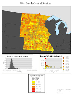
This blog consists of maps of the United States. The purpose of the maps are to show population density in each particular county in the United States. These type of map can give great insight into the distribution of the population in the United states. 5 classes were used to separate and distinguish the data so that it can be analyzed and interpreted better. There is one map which includes all 50 states and there are also 8 more maps that break the up the contiguous United States into distinct regions. Hope you enjoy exploring these maps.


No comments:
Post a Comment